Trail Walking Fontenay-aux-Roses -  Rando des 3 Parcs ! (des Gares RER) - Photo

Rando des 3 Parcs ! (des Gares RER)

 dmj41
dmj41

User

© OpenStreetMap contributors
Length
Length
15.9 km
Max alt
Max alt
172 m
Uphill gradient
Uphill gradient
272 m
Km-Effort
Km-Effort  
19.5 km
Min alt
Min alt
57 m
Downhill gradient
Downhill gradient
274 m
Boucle
Boucle
No
Creation date :
2023-04-18 21:01:10.843
Updated on :
2023-04-26 14:50:33.908

(2 Reviews)

Walking
Walking
4h26
Difficulty : Very difficult

Scan this QR Code to open this trail in the SityTrail application

FREE GPS app for hiking

Logo SityTrail SityTrail

IGN / Geographical institutes

Download SityTrail from the App Store Download SityTrail from Google Play

Logo SityTrail SityTrail World

The world is yours!

Download SityTrail from the App Store Download SityTrail from Google Play Download SityTrail on Huawei AppGallery

About

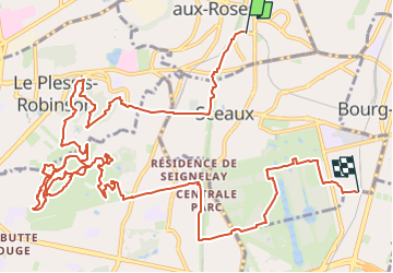
Trail Walking of 15.9 km to be discovered at Ile-de-France, Hauts-de-Seine, Fontenay-aux-Roses. This trail is proposed by dmj41.

Description

Départ : Gare RER B "Fontenay-aux-Roses"
La coulée verte pour faire un petit tour dans le Parc Henri Sellier au  Plessis-Robinson
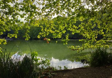
Puis à la Vallée aux Loups de Châtenay-Malabry : Le Parc boisé, la maison de Chateaubriand, le Jardin de l'Aigle blanc, l'Ile verte, et le magnifique Arboretum avec (entre autre) sa serre des bonsaïs
On rejoint ensuite (via la Coulée verte) le parc du domaine de Sceaux
Pour finir à la gare RER B "Parc de Sceaux"

Elevation profile

Positioning

Country:
France
Region :
Ile-de-France
Department/Province :
Hauts-de-Seine
Municipality :
Fontenay-aux-Roses
Location:
Unknown
Start:(UTM)
448005 ; 5404069 (31U) N.

Comments

Please log in to post a review or rate the element


Trails nearby

Trail Walking Verrières-le-Buisson - Sur les sentiers de découverte du Bois de Verrières - Photo
Walking
tracegps

Walking

Medium
(2)
Verrières-le-Buisson, Ile-de-France, Essonne, France
22 km | 27 km-effort
4h 40min
Yes
Trail Walking Sceaux - Les Hauts de Bièvre - Photo
Walking
tracegps

Walking

Difficult
(2)
Sceaux, Ile-de-France, Hauts-de-Seine, France
25 km | 30 km-effort
6h 0min
Yes
Trail Walking Paris - 023 - Paris - De la Cité universitaire aux Halles - Photo
Walking
GUIDE
Rui Barbosa

Walking

Difficult
Paris, Ile-de-France, Paris, France
11.3 km | 12.8 km-effort
2h 54min
No
Trail On foot Antony - Sur la Rive Gauche de la Bièvre - Photo
On foot
PRO

On foot

Easy
Antony, Ile-de-France, Hauts-de-Seine, France
5 km | 6.2 km-effort
1h 24min
No
Trail On foot Paris - 002 - Paris - Street Art 13 eme  - Photo
On foot
GUIDE
Rui Barbosa

On foot

Easy
Paris, Ile-de-France, Paris, France
9.6 km | 10.9 km-effort
2h 29min
No
Trail Walking Clamart - Tour des etangs - Bois de Clamart et de Meudon - Photo
Walking
GUIDE
affinetataille

Walking

Easy
Clamart, Ile-de-France, Hauts-de-Seine, France
8 km | 9.9 km-effort
2h 16min
Yes
Trail Walking Antony - De gare à gare - Photo
Walking
micheldelaramdo

Walking

Easy
(1)
Antony, Ile-de-France, Hauts-de-Seine, France
6.4 km | 7.2 km-effort
1h 29min
No
Trail Walking Paris - porte de  Versailles Notre Dame - Photo
Walking
RoMo

Walking

Easy
Paris, Ile-de-France, Paris, France
10.7 km | 13 km-effort
2h 39min
No
Trail Walking Gentilly - BAGNEUX _ GENTILLY 5 KM - Photo
Walking
gemau77

Walking

Medium
(1)
Gentilly, Ile-de-France, Val-de-Marne, France
5.3 km | 6.2 km-effort
1h 23min
No


Close
My subscriptions