


rando_2023_50km-15753306-r-1681889938-345

thonyc
User GUIDE
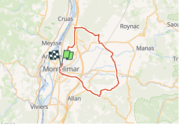

Length
50 km

Max alt
292 m

Uphill gradient
551 m
Km-Effort
57 km

Min alt
79 m

Downhill gradient
550 m
Boucle
Yes
Creation date :
2023-04-19 07:40:07.337
Updated on :
2023-04-22 12:01:16.59
3h27
Difficulty : Very difficult

FREE GPS app for hiking
 SityTrail
IGN / Geographical institutes
SityTrail Plus
The world is yours!
About
Trail Road bike of 50 km to be discovered at Auvergne-Rhône-Alpes, Drôme, Montélimar. This trail is proposed by thonyc.
Positioning
Country:
France
Region :
Auvergne-Rhône-Alpes
Department/Province :
Drôme
Municipality :
Montélimar
Location:
Unknown
Start:(Dec)
Start:(UTM)
639135 ; 4935898 (31T) N.
Comments