


Montelimar Bayne Larnas Lafarre 70km

thonyc
User GUIDE
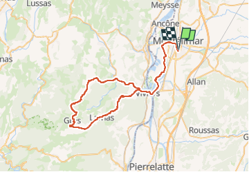

Length
70 km

Max alt
372 m

Uphill gradient
993 m
Km-Effort
83 km

Min alt
60 m

Downhill gradient
994 m
Boucle
Yes
Creation date :
2023-04-19 09:20:56.427
Updated on :
2023-04-20 07:55:09.85
5h03
Difficulty : Medium

FREE GPS app for hiking
 SityTrail
IGN / Geographical institutes
SityTrail Plus
The world is yours!
About
Trail Road bike of 70 km to be discovered at Auvergne-Rhône-Alpes, Drôme, Montélimar. This trail is proposed by thonyc.
Positioning
Country:
France
Region :
Auvergne-Rhône-Alpes
Department/Province :
Drôme
Municipality :
Montélimar
Location:
Unknown
Start:(Dec)
Start:(UTM)
639192 ; 4933895 (31T) N.
Comments