


St Martin de la Cluze- Belvédère du barrage de Monteynard

maupassant38
User
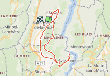

Length
22 km

Max alt
821 m

Uphill gradient
694 m
Km-Effort
32 km

Min alt
569 m

Downhill gradient
693 m
Boucle
Yes
Creation date :
2023-04-19 08:33:07.531
Updated on :
2023-04-19 14:25:14.74
1h39
Difficulty : Medium

FREE GPS app for hiking
 SityTrail
IGN / Geographical institutes
SityTrail Plus
The world is yours!
About
Trail Mountain bike of 22 km to be discovered at Auvergne-Rhône-Alpes, Isère, Saint-Martin-de-la-Cluze. This trail is proposed by maupassant38.
Positioning
Country:
France
Region :
Auvergne-Rhône-Alpes
Department/Province :
Isère
Municipality :
Saint-Martin-de-la-Cluze
Location:
Unknown
Start:(Dec)
Start:(UTM)
709711 ; 4984384 (31T) N.
Comments