


niderhoff lorquin

Titinechris
User
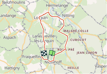

Length
12.2 km

Max alt
325 m

Uphill gradient
158 m
Km-Effort
14.3 km

Min alt
259 m

Downhill gradient
155 m
Boucle
Yes
Creation date :
2023-04-20 08:43:49.17
Updated on :
2023-04-20 08:43:50.924
2h00
Difficulty : Easy

FREE GPS app for hiking
 SityTrail
IGN / Geographical institutes
SityTrail Plus
The world is yours!
About
Trail Running of 12.2 km to be discovered at Grand Est, Moselle, Niderhoff. This trail is proposed by Titinechris.
Positioning
Country:
France
Region :
Grand Est
Department/Province :
Moselle
Municipality :
Niderhoff
Location:
Unknown
Start:(Dec)
Start:(UTM)
353180 ; 5389068 (32U) N.
Comments