


haut des planches ganaux vala

Titinechris
User
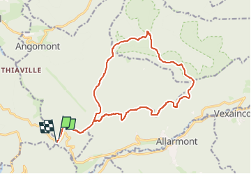

Length
17.7 km

Max alt
666 m

Uphill gradient
564 m
Km-Effort
25 km

Min alt
371 m

Downhill gradient
569 m
Boucle
Yes
Creation date :
2023-04-20 13:31:15.311
Updated on :
2023-04-20 13:31:17.75
3h00
Difficulty : Very easy

FREE GPS app for hiking
 SityTrail
IGN / Geographical institutes
SityTrail Plus
The world is yours!
About
Trail Running of 17.7 km to be discovered at Grand Est, Meurthe-et-Moselle, Angomont. This trail is proposed by Titinechris.
Positioning
Country:
France
Region :
Grand Est
Department/Province :
Meurthe-et-Moselle
Municipality :
Angomont
Location:
Unknown
Start:(Dec)
Start:(UTM)
349042 ; 5372199 (32U) N.
Comments