


sancy2

Titinechris
User

Length
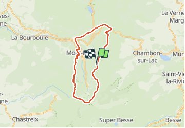
26 km

Max alt
1862 m

Uphill gradient
1492 m
Km-Effort
46 km

Min alt
996 m

Downhill gradient
1484 m
Boucle
Yes
Creation date :
2023-04-21 08:34:36.624
Updated on :
2023-04-21 08:35:36.116
0m
Difficulty : Medium

FREE GPS app for hiking
 SityTrail
IGN / Geographical institutes
SityTrail Plus
The world is yours!
About
Trail Trail of 26 km to be discovered at Auvergne-Rhône-Alpes, Puy-de-Dôme, Mont-Dore. This trail is proposed by Titinechris.
Positioning
Country:
France
Region :
Auvergne-Rhône-Alpes
Department/Province :
Puy-de-Dôme
Municipality :
Mont-Dore
Location:
Unknown
Start:(Dec)
Start:(UTM)
486721 ; 5045561 (31T) N.
Comments