


hauterive

pjoly
User

Length
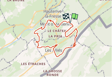
18.1 km

Max alt
1162 m

Uphill gradient
565 m
Km-Effort
26 km

Min alt
859 m

Downhill gradient
566 m
Boucle
Yes
Creation date :
2023-04-21 08:45:48.738
Updated on :
2023-04-21 10:44:36.806
1h58
Difficulty : Medium

FREE GPS app for hiking
 SityTrail
IGN / Geographical institutes
SityTrail Plus
The world is yours!
About
Trail Mountain bike of 18.1 km to be discovered at Bourgogne-Franche-Comté, Doubs, Hauterive-la-Fresse. This trail is proposed by pjoly.
Description
vtt
Positioning
Country:
France
Region :
Bourgogne-Franche-Comté
Department/Province :
Doubs
Municipality :
Hauterive-la-Fresse
Location:
Unknown
Start:(Dec)
Start:(UTM)
307182 ; 5204828 (32T) N.
Comments