


seurre

JL GUILLEMOTE
User
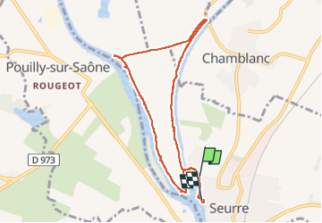

Length
8.5 km

Max alt
183 m

Uphill gradient
55 m
Km-Effort
9.2 km

Min alt
168 m

Downhill gradient
54 m
Boucle
No
Creation date :
2023-04-21 09:43:59.755
Updated on :
2023-04-21 12:03:17.909
2h18
Difficulty : Medium

FREE GPS app for hiking
 SityTrail
IGN / Geographical institutes
SityTrail Plus
The world is yours!
About
Trail Walking of 8.5 km to be discovered at Bourgogne-Franche-Comté, Côte-d'Or, Seurre. This trail is proposed by JL GUILLEMOTE.
Positioning
Country:
France
Region :
Bourgogne-Franche-Comté
Department/Province :
Côte-d'Or
Municipality :
Seurre
Location:
Unknown
Start:(Dec)
Start:(UTM)
662921 ; 5207818 (31T) N.
Comments