


Saint Cyr chemin des vignes

lorenzot54
User
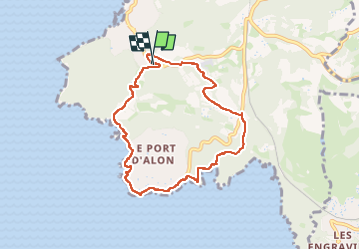

Length
8.1 km

Max alt
74 m

Uphill gradient
167 m
Km-Effort
10.3 km

Min alt
6 m

Downhill gradient
159 m
Boucle
Yes
Creation date :
2023-04-22 13:35:25.0
Updated on :
2023-04-22 17:23:07.706
2h35
Difficulty : Medium

FREE GPS app for hiking
 SityTrail
IGN / Geographical institutes
SityTrail Plus
The world is yours!
About
Trail Walking of 8.1 km to be discovered at Provence-Alpes-Côte d'Azur, Var, Saint-Cyr-sur-Mer. This trail is proposed by lorenzot54.
Positioning
Country:
France
Region :
Provence-Alpes-Côte d'Azur
Department/Province :
Var
Municipality :
Saint-Cyr-sur-Mer
Location:
Unknown
Start:(Dec)
Start:(UTM)
719405 ; 4782137 (31T) N.
Comments