


rochecorbon

BrassensJC
User
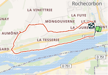

Length
4.6 km

Max alt
102 m

Uphill gradient
65 m
Km-Effort
5.5 km

Min alt
44 m

Downhill gradient
62 m
Boucle
Yes
Creation date :
2023-04-24 10:31:50.992
Updated on :
2023-04-24 11:48:11.651
1h15
Difficulty : Easy

FREE GPS app for hiking
 SityTrail
IGN / Geographical institutes
SityTrail Plus
The world is yours!
About
Trail Walking of 4.6 km to be discovered at Centre-Loire Valley, Indre-et-Loire, Rochecorbon. This trail is proposed by BrassensJC.
Positioning
Country:
France
Region :
Centre-Loire Valley
Department/Province :
Indre-et-Loire
Municipality :
Rochecorbon
Location:
Unknown
Start:(Dec)
Start:(UTM)
330785 ; 5252923 (31T) N.
Comments