


Burnontige eneo 15km

dechathys
User
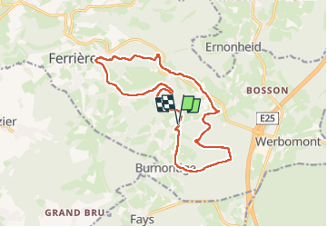

Length
14.7 km

Max alt
438 m

Uphill gradient
316 m
Km-Effort
18.9 km

Min alt
219 m

Downhill gradient
316 m
Boucle
Yes
Creation date :
2023-04-11 07:48:52.529
Updated on :
2023-04-24 13:05:52.858
4h31
Difficulty : Medium

FREE GPS app for hiking
 SityTrail
IGN / Geographical institutes
SityTrail Plus
The world is yours!
About
Trail Walking of 14.7 km to be discovered at Wallonia, Liège, Ferrières. This trail is proposed by dechathys.
Positioning
Country:
Belgium
Region :
Wallonia
Department/Province :
Liège
Municipality :
Ferrières
Location:
Unknown
Start:(Dec)
Start:(UTM)
688056 ; 5584686 (31U) N.
Comments