


BM Boissy Sucy 10km reconnaissance

jeanmarcMasson
User GUIDE
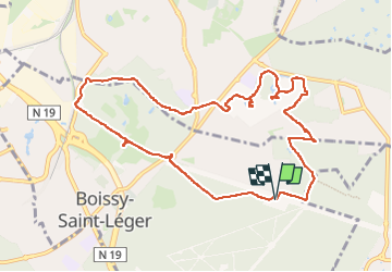

Length
10.5 km

Max alt
109 m

Uphill gradient
101 m
Km-Effort
11.8 km

Min alt
48 m

Downhill gradient
100 m
Boucle
Yes
Creation date :
2023-04-24 12:24:14.0
Updated on :
2023-04-24 15:19:23.308
2h23
Difficulty : Unknown

FREE GPS app for hiking
 SityTrail
IGN / Geographical institutes
SityTrail Plus
The world is yours!
About
Trail Walking of 10.5 km to be discovered at Ile-de-France, Val-de-Marne, Boissy-Saint-Léger. This trail is proposed by jeanmarcMasson.
Positioning
Country:
France
Region :
Ile-de-France
Department/Province :
Val-de-Marne
Municipality :
Boissy-Saint-Léger
Location:
Unknown
Start:(Dec)
Start:(UTM)
466151 ; 5399667 (31U) N.
Comments