


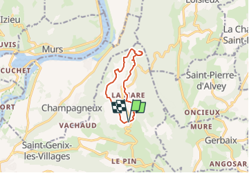
MONT TOURNIER depuis St Maurice de Rotherens

papou73
User

Length
9.3 km

Max alt
874 m

Uphill gradient
298 m
Km-Effort
13.3 km

Min alt
626 m

Downhill gradient
297 m
Boucle
Yes
Creation date :
2023-04-24 15:51:30.912
Updated on :
2023-04-24 15:52:28.205
3h00
Difficulty : Difficult

FREE GPS app for hiking
 SityTrail
IGN / Geographical institutes
SityTrail Plus
The world is yours!
About
Trail Walking of 9.3 km to be discovered at Auvergne-Rhône-Alpes, Savoy, Saint-Genix-les-Villages. This trail is proposed by papou73.
Positioning
Country:
France
Region :
Auvergne-Rhône-Alpes
Department/Province :
Savoy
Municipality :
Saint-Genix-les-Villages
Location:
Saint-Maurice-de-Rotherens
Start:(Dec)
Start:(UTM)
710504 ; 5054902 (31T) N.
Comments