


2023-04-24_18h53m02_iti0054

jeanic63
User
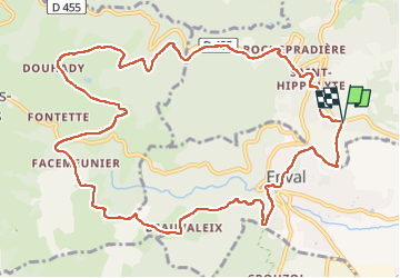

Length
13.7 km

Max alt
733 m

Uphill gradient
418 m
Km-Effort
19.2 km

Min alt
437 m

Downhill gradient
416 m
Boucle
Yes
Creation date :
2023-04-24 16:53:03.734
Updated on :
2023-04-24 16:57:22.007
4h22
Difficulty : Easy

FREE GPS app for hiking
 SityTrail
IGN / Geographical institutes
SityTrail Plus
The world is yours!
About
Trail On foot of 13.7 km to be discovered at Auvergne-Rhône-Alpes, Puy-de-Dôme, Châtel-Guyon. This trail is proposed by jeanic63.
Description
départ parking stade de Chatel Guyon
Positioning
Country:
France
Region :
Auvergne-Rhône-Alpes
Department/Province :
Puy-de-Dôme
Municipality :
Châtel-Guyon
Location:
Unknown
Start:(Dec)
Start:(UTM)
504589 ; 5083583 (31T) N.
Comments