


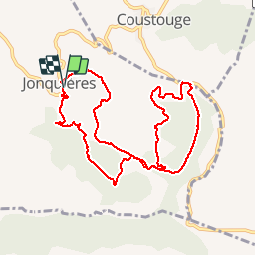
11-Jonquieres : Le Trou des Gimboul-Les Bergeries Ruinées

Jovila
User

Length
10.8 km

Max alt
373 m

Uphill gradient
289 m
Km-Effort
14.7 km

Min alt
203 m

Downhill gradient
293 m
Boucle
Yes
Creation date :
2015-03-26 00:00:00.0
Updated on :
2015-03-26 00:00:00.0
3h10
Difficulty : Easy

FREE GPS app for hiking
 SityTrail
IGN / Geographical institutes
SityTrail Plus
The world is yours!
About
Trail Walking of 10.8 km to be discovered at Occitania, Aude, Jonquières. This trail is proposed by Jovila.
Description
Départ : à la sortie du village au réservoir à eau.
Positioning
Country:
France
Region :
Occitania
Department/Province :
Aude
Municipality :
Jonquières
Location:
Unknown
Start:(Dec)
Start:(UTM)
477997 ; 4765158 (31T) N.
Comments