


Saint Laurent d'Agny-La chapelle St Vincent-Rhone

ThierryJ01
User
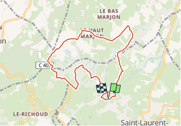

Length
9 km

Max alt
539 m

Uphill gradient
193 m
Km-Effort
11.5 km

Min alt
394 m

Downhill gradient
196 m
Boucle
Yes
Creation date :
2023-04-24 20:35:18.34
Updated on :
2023-04-24 20:36:43.38
2h37
Difficulty : Medium

FREE GPS app for hiking
 SityTrail
IGN / Geographical institutes
SityTrail Plus
The world is yours!
About
Trail Walking of 9 km to be discovered at Auvergne-Rhône-Alpes, Rhône, Saint-Laurent-d'Agny. This trail is proposed by ThierryJ01.
Positioning
Country:
France
Region :
Auvergne-Rhône-Alpes
Department/Province :
Rhône
Municipality :
Saint-Laurent-d'Agny
Location:
Unknown
Start:(Dec)
Start:(UTM)
630359 ; 5056136 (31T) N.
Comments