hattonchatel seuzey

ochelen
User
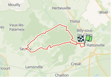

Length
27 km

Max alt
412 m

Uphill gradient
437 m
Km-Effort
33 km

Min alt
241 m

Downhill gradient
433 m
Boucle
Yes
Creation date :
2023-04-25 08:16:12.963
Updated on :
2023-04-25 08:21:11.83
0m
Difficulty : Medium

FREE GPS app for hiking
 SityTrail
IGN / Geographical institutes
SityTrail Plus
The world is yours!
About
Trail Equestrian of 27 km to be discovered at Grand Est, Meuse, Vigneulles-lès-Hattonchâtel. This trail is proposed by ochelen.
Positioning
Country:
France
Region :
Grand Est
Department/Province :
Meuse
Municipality :
Vigneulles-lès-Hattonchâtel
Location:
Hattonchâtel
Start:(Dec)
Start:(UTM)
696814 ; 5429996 (31U) N.
Comments