


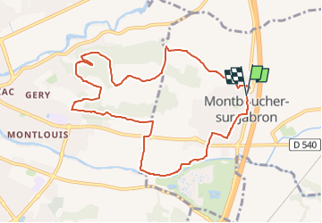
Montboucher-Bois Lion-Jabron 10km

thonyc
User GUIDE

Length
10.4 km

Max alt
167 m

Uphill gradient
166 m
Km-Effort
12.6 km

Min alt
98 m

Downhill gradient
173 m
Boucle
Yes
Creation date :
2023-04-25 16:37:59.167
Updated on :
2023-04-25 16:38:50.794
2h52
Difficulty : Difficult

FREE GPS app for hiking
 SityTrail
IGN / Geographical institutes
SityTrail Plus
The world is yours!
About
Trail Walking of 10.4 km to be discovered at Auvergne-Rhône-Alpes, Drôme, Montboucher-sur-Jabron. This trail is proposed by thonyc.
Positioning
Country:
France
Region :
Auvergne-Rhône-Alpes
Department/Province :
Drôme
Municipality :
Montboucher-sur-Jabron
Location:
Unknown
Start:(Dec)
Start:(UTM)
643656 ; 4935069 (31T) N.
Comments