


saint hippolyte montaclier modifier 1

jeanic63
User
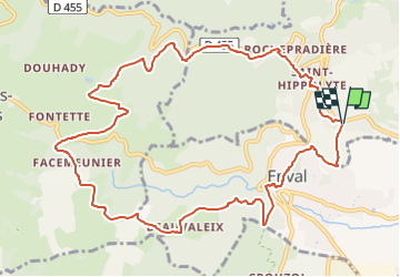

Length
12.4 km

Max alt
733 m

Uphill gradient
409 m
Km-Effort
17.8 km

Min alt
433 m

Downhill gradient
404 m
Boucle
Yes
Creation date :
2023-04-27 18:31:03.847
Updated on :
2023-04-27 18:34:00.098
4h02
Difficulty : Easy

FREE GPS app for hiking
 SityTrail
IGN / Geographical institutes
SityTrail Plus
The world is yours!
About
Trail On foot of 12.4 km to be discovered at Auvergne-Rhône-Alpes, Puy-de-Dôme, Châtel-Guyon. This trail is proposed by jeanic63.
Description
départ stade de la Croze saint Hippolyte
Positioning
Country:
France
Region :
Auvergne-Rhône-Alpes
Department/Province :
Puy-de-Dôme
Municipality :
Châtel-Guyon
Location:
Unknown
Start:(Dec)
Start:(UTM)
504577 ; 5083569 (31T) N.
Comments