


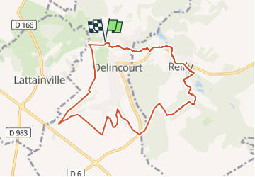
Delincourt / le marais de Reilly le haut des masures/

serge.guerroult
User

Length
8.9 km

Max alt
148 m

Uphill gradient
141 m
Km-Effort
10.8 km

Min alt
72 m

Downhill gradient
140 m
Boucle
Yes
Creation date :
2023-04-29 08:03:38.246
Updated on :
2023-05-01 17:04:16.038
2h26
Difficulty : Medium

FREE GPS app for hiking
 SityTrail
IGN / Geographical institutes
SityTrail Plus
The world is yours!
About
Trail Walking of 8.9 km to be discovered at Hauts-de-France, Oise, Delincourt. This trail is proposed by serge.guerroult.
Positioning
Country:
France
Region :
Hauts-de-France
Department/Province :
Oise
Municipality :
Delincourt
Location:
Unknown
Start:(Dec)
Start:(UTM)
414799 ; 5455571 (31U) N.
Comments