


La Louisianne

lorenzot54
User
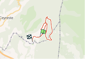

Length
7 km

Max alt
337 m

Uphill gradient
166 m
Km-Effort
9.3 km

Min alt
177 m

Downhill gradient
185 m
Boucle
No
Creation date :
2023-04-28 14:59:42.0
Updated on :
2023-04-29 09:11:07.961
2h00
Difficulty : Medium

FREE GPS app for hiking
 SityTrail
IGN / Geographical institutes
SityTrail Plus
The world is yours!
About
Trail Walking of 7 km to be discovered at Provence-Alpes-Côte d'Azur, Bouches-du-Rhône, Ceyreste. This trail is proposed by lorenzot54.
Description
Vue sur La Ciotat, différentes bories restaurer
Positioning
Country:
France
Region :
Provence-Alpes-Côte d'Azur
Department/Province :
Bouches-du-Rhône
Municipality :
Ceyreste
Location:
Unknown
Start:(Dec)
Start:(UTM)
716394 ; 4787383 (31T) N.
Comments