


sortie St quirin

Titinechris
User
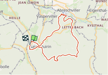

Length
17.3 km

Max alt
500 m

Uphill gradient
578 m
Km-Effort
25 km

Min alt
304 m

Downhill gradient
580 m
Boucle
Yes
Creation date :
2023-04-29 18:11:12.998
Updated on :
2023-04-29 18:11:15.115
2h00
Difficulty : Very easy

FREE GPS app for hiking
 SityTrail
IGN / Geographical institutes
SityTrail Plus
The world is yours!
About
Trail Trail of 17.3 km to be discovered at Grand Est, Moselle, Saint-Quirin. This trail is proposed by Titinechris.
Positioning
Country:
France
Region :
Grand Est
Department/Province :
Moselle
Municipality :
Saint-Quirin
Location:
Unknown
Start:(Dec)
Start:(UTM)
356557 ; 5386009 (32U) N.
Comments