


Rochefort-Frandeux

pierlan
User
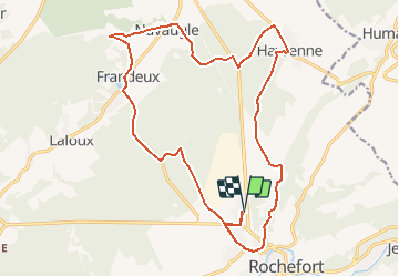

Length
19.2 km

Max alt
261 m

Uphill gradient
323 m
Km-Effort
23 km

Min alt
161 m

Downhill gradient
323 m
Boucle
Yes
Creation date :
2014-12-10 00:00:00.0
Updated on :
2020-10-30 14:47:23.925
3h00
Difficulty : Unknown

FREE GPS app for hiking
 SityTrail
IGN / Geographical institutes
SityTrail Plus
The world is yours!
About
Trail Other activity of 19.2 km to be discovered at Wallonia, Namur, Rochefort. This trail is proposed by pierlan.
Positioning
Country:
Belgium
Region :
Wallonia
Department/Province :
Namur
Municipality :
Rochefort
Location:
Rochefort
Start:(Dec)
Start:(UTM)
657844 ; 5559836 (31U) N.
Comments