Trail Walking Sury-en-Vaux - Morogues entre lés vignes  - Photo

Morogues entre lés vignes

© OpenStreetMap contributors
Length
Length
10.1 km
Max alt
Max alt
299 m
Uphill gradient
Uphill gradient
197 m
Km-Effort
Km-Effort  
12.7 km
Min alt
Min alt
183 m
Downhill gradient
Downhill gradient
195 m
Boucle
Boucle
Yes
Creation date :
2023-04-30 10:51:13.0
Updated on :
2023-04-30 14:00:05.112

(0 Reviews)

Walking
Walking
2h37
Difficulty : Difficult

Scan this QR Code to open this trail in the SityTrail application

FREE GPS app for hiking

Logo SityTrail SityTrail

IGN / Geographical institutes

Download SityTrail from the App Store Download SityTrail from Google Play

Logo SityTrail SityTrail World

The world is yours!

Download SityTrail from the App Store Download SityTrail from Google Play Download SityTrail on Huawei AppGallery

About

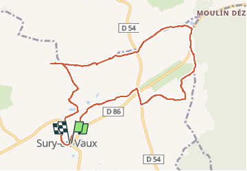
Trail Walking of 10.1 km to be discovered at Centre-Loire Valley, Cher, Sury-en-Vaux. This trail is proposed by sabrigault.

Description

Au pied de Sancerre, belle randonnée entre les vignes
Trace prise à l’office du tourisme

Elevation profile

Positioning

Country:
France
Region :
Centre-Loire Valley
Department/Province :
Cher
Municipality :
Sury-en-Vaux
Location:
Unknown
Start:(UTM)
485321 ; 5246114 (31T) N.

Trails nearby

Trail Walking Saint-Satur - Saint-Thibault-sur-Loire - Photo
Walking
Ordijamo45

Walking

Medium
(1)
Saint-Satur, Centre-Loire Valley, Cher, France
11.5 km | 14 km-effort
3h 2min
Yes
Trail Walking Saint-Satur - Randonnée autour de Saint Satur - Photo
Walking
Ecureuiltrailer

Walking

Very easy
Saint-Satur, Centre-Loire Valley, Cher, France
11.4 km | 13.9 km-effort
2h 47min
Yes
Trail Nordic walking Saint-Satur - randonnée des 3 viaduc - Photo
Nordic walking
levequejef

Nordic walking

Easy
Saint-Satur, Centre-Loire Valley, Cher, France
24 km | 29 km-effort
3h 45min
Yes
Trail Nordic walking Sury-en-Vaux - boucle sury en vaux  - Photo
Nordic walking
levequejef

Nordic walking

Very easy
Sury-en-Vaux, Centre-Loire Valley, Cher, France
12.1 km | 15.6 km-effort
2h 5min
Yes
Trail Trail Sancerre - trail Sancerre emb - Photo
Trail
zobio

Trail

Very easy
Sancerre, Centre-Loire Valley, Cher, France
12.3 km | 17.1 km-effort
4h 25min
Yes
Trail Road bike Saint-Satur - u6 - Photo
Road bike
eymerick

Road bike

Very difficult
Saint-Satur, Centre-Loire Valley, Cher, France
51 km | 56 km-effort
3h 10min
No
Trail Walking Sancerre - La ronde des Sorcières - Photo
Walking
dhommee

Walking

Medium
Sancerre, Centre-Loire Valley, Cher, France
19.1 km | 25 km-effort
3h 50min
Yes
Trail On foot Sancerre - 2021-10-11_20h38m14_Sancerre - Photo
On foot
Ordijamo45

On foot

Medium
Sancerre, Centre-Loire Valley, Cher, France
8.5 km | 11.1 km-effort
2h 31min
Yes
Trail Walking Verdigny - Verdigny, Sury en vaux et moulins à vent - Photo
Walking
Jjlerat

Walking

Difficult
Verdigny, Centre-Loire Valley, Cher, France
10.9 km | 14.7 km-effort
3h 6min
Yes


Close
My subscriptions