


reherrey hablainville

Titinechris
User
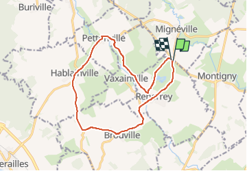

Length
14.1 km

Max alt
342 m

Uphill gradient
190 m
Km-Effort
16.6 km

Min alt
249 m

Downhill gradient
186 m
Boucle
Yes
Creation date :
2023-05-01 05:50:46.595
Updated on :
2023-05-01 05:51:32.481
0m
Difficulty : Easy

FREE GPS app for hiking
 SityTrail
IGN / Geographical institutes
SityTrail Plus
The world is yours!
About
Trail Running of 14.1 km to be discovered at Grand Est, Meurthe-et-Moselle, Reherrey. This trail is proposed by Titinechris.
Positioning
Country:
France
Region :
Grand Est
Department/Province :
Meurthe-et-Moselle
Municipality :
Reherrey
Location:
Unknown
Start:(Dec)
Start:(UTM)
335917 ; 5376693 (32U) N.
Comments