


2023-05-03 Rando Longpont

jchezlemas
User
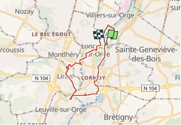

Length
13.2 km

Max alt
129 m

Uphill gradient
161 m
Km-Effort
15.4 km

Min alt
37 m

Downhill gradient
160 m
Boucle
Yes
Creation date :
2023-05-03 07:04:25.679
Updated on :
2023-05-03 16:23:27.953
2h49
Difficulty : Easy

FREE GPS app for hiking
 SityTrail
IGN / Geographical institutes
SityTrail Plus
The world is yours!
About
Trail Walking of 13.2 km to be discovered at Ile-de-France, Essonne, Sainte-Geneviève-des-Bois. This trail is proposed by jchezlemas.
Positioning
Country:
France
Region :
Ile-de-France
Department/Province :
Essonne
Municipality :
Sainte-Geneviève-des-Bois
Location:
Unknown
Start:(Dec)
Start:(UTM)
448310 ; 5388183 (31U) N.
Comments