Trail Walking Montpeyroux - Le château du Bousquet - Photo

Le château du Bousquet

 Lacaze
Lacaze

User

© OpenStreetMap contributors
Length
Length
7.8 km
Max alt
Max alt
964 m
Uphill gradient
Uphill gradient
202 m
Km-Effort
Km-Effort  
10.5 km
Min alt
Min alt
870 m
Downhill gradient
Downhill gradient
201 m
Boucle
Boucle
Yes
Creation date :
2014-12-10 00:00:00.0
Updated on :
2014-12-10 00:00:00.0

(1 Reviews)

Walking
Walking
2h13
Difficulty : Medium

Scan this QR Code to open this trail in the SityTrail application

FREE GPS app for hiking

Logo SityTrail SityTrail

IGN / Geographical institutes

Download SityTrail from the App Store Download SityTrail from Google Play

Logo SityTrail SityTrail World

The world is yours!

Download SityTrail from the App Store Download SityTrail from Google Play Download SityTrail on Huawei AppGallery

About

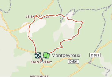
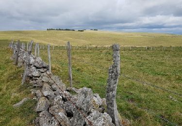
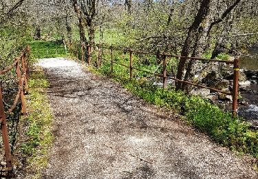
Trail Walking of 7.8 km to be discovered at Occitania, Aveyron, Montpeyroux. This trail is proposed by Lacaze.

Description

Départ de St-Remy de Bedène.
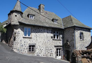
A voir le château après le Bousquet le chemin pour monter à Pinsonnac beaucoup d'eau.De bonnes chaussures sont nécessaires.

Elevation profile

Positioning

Country:
France
Region :
Occitania
Department/Province :
Aveyron
Municipality :
Montpeyroux
Location:
Unknown
Start:(UTM)
484997 ; 4942855 (31T) N.

Comments

Please log in to post a review or rate the element


Trails nearby

Trail Walking Laguiole - Laguiole Pigasse  - Photo
Walking
Galoche

Walking

Easy
Laguiole, Occitania, Aveyron, France
6.2 km | 8.4 km-effort
1h 47min
Yes
Trail Walking Curières - la croix du Pal - Photo
Walking
bidetarou

Walking

Medium
Curières, Occitania, Aveyron, France
15.2 km | 22 km-effort
4h 29min
Yes
Trail On foot Laguiole - Laguiole PR-5 - Photo
On foot
PRO

On foot

Easy
Laguiole, Occitania, Aveyron, France
6.3 km | 8.8 km-effort
1h 59min
No
Trail On foot Condom-d'Aubrac - Sentier Aubrac - Abbaye de Bonneval - Espalion - Photo
On foot
PRO

On foot

Easy
Condom-d'Aubrac, Occitania, Aveyron, France
12.8 km | 19.2 km-effort
4h 21min
No
Trail Walking Laguiole - Tour de l'Aubrac 4 - Photo
Walking
phimar_2612

Walking

Medium
Laguiole, Occitania, Aveyron, France
16.9 km | 22 km-effort
4h 42min
No
Trail Walking Laguiole - laguiole le Bousquet soulages - Photo
Walking
jeanfcd

Walking

Medium
Laguiole, Occitania, Aveyron, France
20 km | 26 km-effort
5h 11min
Yes
Trail Mountain bike Condom-d'Aubrac - Site VTT FFC Aubrac - Vallée du Lot - Circuit n°5 - Les Enguilhens - Photo
Mountain bike
tracegps

Mountain bike

Difficult
(1)
Condom-d'Aubrac, Occitania, Aveyron, France
20 km | 26 km-effort
1h 40min
Yes
Trail Walking Laguiole - 2023-08-03_20h34m40_Cirkwi-Le_roc_des_Cabres - Photo
Walking
neoroll44

Walking

Medium
Laguiole, Occitania, Aveyron, France
12.8 km | 16.9 km-effort
4h 0min
Yes
Trail Walking Curières - 2023-08-01_14h05m13_Cirkwi-La_croix_du_Pal - Photo
Walking
neoroll44

Walking

Medium
Curières, Occitania, Aveyron, France
14.8 km | 21 km-effort
4h 50min
Yes


Close
My subscriptions