


Martagny le Robinet Cuit

serge.guerroult
User
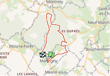

Length
13.3 km

Max alt
200 m

Uphill gradient
211 m
Km-Effort
16.1 km

Min alt
101 m

Downhill gradient
211 m
Boucle
Yes
Creation date :
2023-05-04 07:00:58.357
Updated on :
2023-05-04 10:06:24.217
3h04
Difficulty : Difficult

FREE GPS app for hiking
 SityTrail
IGN / Geographical institutes
SityTrail Plus
The world is yours!
About
Trail Walking of 13.3 km to be discovered at Normandy, Eure, Martagny. This trail is proposed by serge.guerroult.
Positioning
Country:
France
Region :
Normandy
Department/Province :
Eure
Municipality :
Martagny
Location:
Unknown
Start:(Dec)
Start:(UTM)
402583 ; 5472167 (31U) N.
Comments