


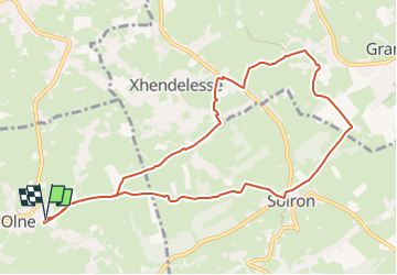
Olne, Xhendelesse, Soiron

Delhezpy
User

Length
9.3 km

Max alt
269 m

Uphill gradient
162 m
Km-Effort
11.5 km

Min alt
202 m

Downhill gradient
161 m
Boucle
Yes
Creation date :
2023-05-04 13:02:31.465
Updated on :
2023-05-04 13:05:30.549
2h36
Difficulty : Medium

FREE GPS app for hiking
 SityTrail
IGN / Geographical institutes
SityTrail Plus
The world is yours!
About
Trail Walking of 9.3 km to be discovered at Wallonia, Liège, Olne. This trail is proposed by Delhezpy.
Positioning
Country:
Belgium
Region :
Wallonia
Department/Province :
Liège
Municipality :
Olne
Location:
Unknown
Start:(Dec)
Start:(UTM)
694825 ; 5607867 (31U) N.
Comments