


La Jarjatte - Lac Lauzon- Refuge de la croix

Atchoum26
User
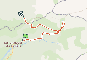

Length
7.4 km

Max alt
1932 m

Uphill gradient
728 m
Km-Effort
16.4 km

Min alt
1233 m

Downhill gradient
497 m
Boucle
No
Creation date :
2023-03-15 08:38:11.544
Updated on :
2023-05-06 08:23:23.146
5h06
Difficulty : Medium

FREE GPS app for hiking
 SityTrail
IGN / Geographical institutes
SityTrail Plus
The world is yours!
About
Trail Walking of 7.4 km to be discovered at Auvergne-Rhône-Alpes, Drôme, Lus-la-Croix-Haute. This trail is proposed by Atchoum26.
Photos


Positioning
Country:
France
Region :
Auvergne-Rhône-Alpes
Department/Province :
Drôme
Municipality :
Lus-la-Croix-Haute
Location:
Unknown
Start:(Dec)
Start:(UTM)
720219 ; 4952439 (31T) N.
Comments