


refuge de la Croix - La Jarjatte

Atchoum26
User
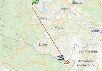

Length
31 km

Max alt
1785 m

Uphill gradient
1967 m
Km-Effort
56 km

Min alt
535 m

Downhill gradient
1526 m
Boucle
No
Creation date :
2023-03-16 07:33:49.738
Updated on :
2023-05-06 08:23:24.482
2h52
Difficulty : Easy

FREE GPS app for hiking
 SityTrail
IGN / Geographical institutes
SityTrail Plus
The world is yours!
About
Trail Walking of 31 km to be discovered at Auvergne-Rhône-Alpes, Isère, Roissard. This trail is proposed by Atchoum26.
Positioning
Country:
France
Region :
Auvergne-Rhône-Alpes
Department/Province :
Isère
Municipality :
Roissard
Location:
Unknown
Start:(Dec)
Start:(UTM)
706959 ; 4973820 (31T) N.
Comments