


Mont Rachas tracé Manu

Atchoum26
User
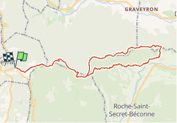

Length
22 km

Max alt
894 m

Uphill gradient
912 m
Km-Effort
34 km

Min alt
379 m

Downhill gradient
912 m
Boucle
Yes
Creation date :
2023-05-06 14:00:49.0
Updated on :
2023-05-06 14:00:54.487
0m
Difficulty : Unknown

FREE GPS app for hiking
 SityTrail
IGN / Geographical institutes
SityTrail Plus
The world is yours!
About
Trail Trail of 22 km to be discovered at Auvergne-Rhône-Alpes, Drôme, Aleyrac. This trail is proposed by Atchoum26.
Positioning
Country:
France
Region :
Auvergne-Rhône-Alpes
Department/Province :
Drôme
Municipality :
Aleyrac
Location:
Unknown
Start:(Dec)
Start:(UTM)
654759 ; 4928878 (31T) N.
Comments