


Circuit no 9 jusqu’à terminions puis trop de neige pour monter au mont c

phil21
User
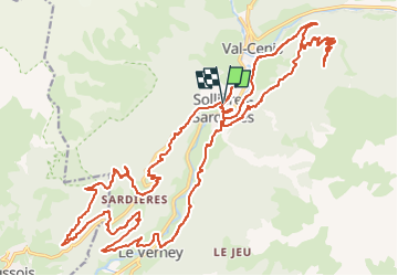

Length
36 km

Max alt
1879 m

Uphill gradient
1313 m
Km-Effort
54 km

Min alt
1223 m

Downhill gradient
1312 m
Boucle
Yes
Creation date :
2023-05-06 12:17:23.0
Updated on :
2023-05-06 15:48:58.01
3h30
Difficulty : Difficult

FREE GPS app for hiking
 SityTrail
IGN / Geographical institutes
SityTrail Plus
The world is yours!
About
Trail Electric bike of 36 km to be discovered at Auvergne-Rhône-Alpes, Savoy, Val-Cenis. This trail is proposed by phil21.
Positioning
Country:
France
Region :
Auvergne-Rhône-Alpes
Department/Province :
Savoy
Municipality :
Val-Cenis
Location:
Sollières-Sardières
Start:(Dec)
Start:(UTM)
328045 ; 5014720 (32T) N.
Comments