


cayriech

82240gerard
User
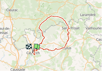

Length
63 km

Max alt
399 m

Uphill gradient
989 m
Km-Effort
76 km

Min alt
148 m

Downhill gradient
989 m
Boucle
Yes
Creation date :
2023-05-07 06:28:52.306
Updated on :
2023-05-07 11:10:52.262
4h03
Difficulty : Very difficult

FREE GPS app for hiking
 SityTrail
IGN / Geographical institutes
SityTrail Plus
The world is yours!
About
Trail Mountain bike of 63 km to be discovered at Occitania, Tarn-et-Garonne, Cayriech. This trail is proposed by 82240gerard.
Positioning
Country:
France
Region :
Occitania
Department/Province :
Tarn-et-Garonne
Municipality :
Cayriech
Location:
Unknown
Start:(Dec)
Start:(UTM)
389058 ; 4897132 (31T) N.
Comments