


2023-05-07_13h59m58_7baeb8a3-12cd-4680-846b-5fce57d862ea

phi14
User

Length
10.9 km

Max alt
159 m

Uphill gradient
224 m
Km-Effort
13.9 km

Min alt
72 m

Downhill gradient
226 m
Boucle
Yes
Creation date :
2023-05-07 11:59:58.931
Updated on :
2023-05-14 19:14:39.396
0m
Difficulty : Easy

FREE GPS app for hiking
 SityTrail
IGN / Geographical institutes
SityTrail Plus
The world is yours!
About
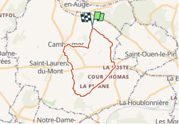
Trail Nordic walking of 10.9 km to be discovered at Normandy, Calvados, Cambremer. This trail is proposed by phi14.
Description
Belle balade au coeur du pays d'Auge. Un jardin remarquable se trouve sur le parcours. On peut y manger des bonnes crêpes et au manoir de Grandouet dégustation de cidre obligatoire !
Positioning
Country:
France
Region :
Normandy
Department/Province :
Calvados
Municipality :
Cambremer
Location:
Cambremer
Start:(Dec)
Start:(UTM)
286111 ; 5449307 (31U) N.
Comments