


ROUXMESNILS-BOUTEILLES

juanluco76
User
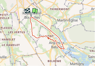

Length
10.7 km

Max alt
94 m

Uphill gradient
132 m
Km-Effort
12.4 km

Min alt
0 m

Downhill gradient
132 m
Boucle
Yes
Creation date :
2023-05-07 15:29:34.921
Updated on :
2023-05-07 15:30:46.032
2h49
Difficulty : Difficult

FREE GPS app for hiking
 SityTrail
IGN / Geographical institutes
SityTrail Plus
The world is yours!
About
Trail Walking of 10.7 km to be discovered at Normandy, Seine-Maritime, Rouxmesnil-Bouteilles. This trail is proposed by juanluco76.
Positioning
Country:
France
Region :
Normandy
Department/Province :
Seine-Maritime
Municipality :
Rouxmesnil-Bouteilles
Location:
Unknown
Start:(Dec)
Start:(UTM)
363082 ; 5529734 (31U) N.
Comments