


DOURDAN SUD

jpcccb
User
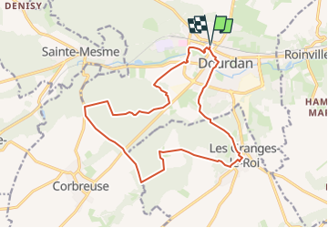

Length
16.6 km

Max alt
168 m

Uphill gradient
288 m
Km-Effort
20 km

Min alt
94 m

Downhill gradient
287 m
Boucle
Yes
Creation date :
2023-05-08 10:58:14.931
Updated on :
2023-05-08 11:16:00.799
4h38
Difficulty : Very difficult

FREE GPS app for hiking
 SityTrail
IGN / Geographical institutes
SityTrail Plus
The world is yours!
About
Trail Walking of 16.6 km to be discovered at Ile-de-France, Essonne, Dourdan. This trail is proposed by jpcccb.
Positioning
Country:
France
Region :
Ile-de-France
Department/Province :
Essonne
Municipality :
Dourdan
Location:
Unknown
Start:(Dec)
Start:(UTM)
426893 ; 5376053 (31U) N.
Comments