Olhain

Blourouce
User
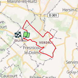

Length
11.7 km

Max alt
195 m

Uphill gradient
193 m
Km-Effort
14.3 km

Min alt
85 m

Downhill gradient
193 m
Boucle
Yes
Creation date :
2019-01-12 16:54:35.468
Updated on :
2019-01-12 16:54:35.473
3h06
Difficulty : Easy

FREE GPS app for hiking
 SityTrail
IGN / Geographical institutes
SityTrail Plus
The world is yours!
About
Trail Walking of 11.7 km to be discovered at Hauts-de-France, Pas-de-Calais, Fresnicourt-le-Dolmen. This trail is proposed by Blourouce.
Positioning
Country:
France
Region :
Hauts-de-France
Department/Province :
Pas-de-Calais
Municipality :
Fresnicourt-le-Dolmen
Location:
Unknown
Start:(Dec)
Start:(UTM)
470611 ; 5585889 (31U) N.
Comments