Trail Walking Saint-Maurice-de-Lignon - 
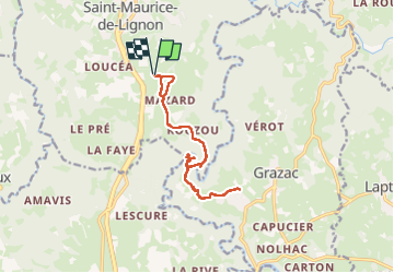
saint Maurice de Lignon Grazac - Photo
© OpenStreetMap contributors
Length
Length
14.2 km
Max alt
Max alt
811 m
Uphill gradient
Uphill gradient
513 m
Km-Effort
Km-Effort  
21 km
Min alt
Min alt
611 m
Downhill gradient
Downhill gradient
516 m
Boucle
Boucle
Yes
Creation date :
2023-05-09 06:27:53.04
Updated on :
2023-05-09 10:23:18.722

(0 Reviews)

Walking
Walking
3h09
Difficulty : Medium

Scan this QR Code to open this trail in the SityTrail application

FREE GPS app for hiking

Logo SityTrail SityTrail

IGN / Geographical institutes

Download SityTrail from the App Store Download SityTrail from Google Play

Logo SityTrail SityTrail Plus

The world is yours!

Download SityTrail from the App Store Download SityTrail from Google Play Download SityTrail on Huawei AppGallery

About

Trail Walking of 14.2 km to be discovered at Auvergne-Rhône-Alpes, Haute-Loire, Saint-Maurice-de-Lignon. This trail is proposed by alinetpierre.

Description

Passerelles himalayennes,le dépaysement sans les km
descente dans le Lignon à faire que si bien chaussé, sinon randonnée facile.

Elevation profile

Photos

22 photos in total. Please click on a photo to see them all in the gallery.

Positioning

Country:
France
Region :
Auvergne-Rhône-Alpes
Department/Province :
Haute-Loire
Municipality :
Saint-Maurice-de-Lignon
Location:
Unknown
Start:(UTM)
589928 ; 5006905 (31T) N.


Close
My subscriptions