


20230509-Charleval

doudet
User
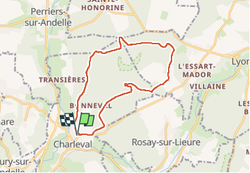

Length
13.8 km

Max alt
169 m

Uphill gradient
228 m
Km-Effort
16.8 km

Min alt
38 m

Downhill gradient
228 m
Boucle
Yes
Creation date :
2023-05-09 12:00:11.437
Updated on :
2023-05-14 07:57:15.945
3h46
Difficulty : Medium

FREE GPS app for hiking
 SityTrail
IGN / Geographical institutes
SityTrail Plus
The world is yours!
About
Trail Walking of 13.8 km to be discovered at Normandy, Eure, Charleval. This trail is proposed by doudet.
Description
Boucle A-R au départ du Cimetière
Photos


Positioning
Country:
France
Region :
Normandy
Department/Province :
Eure
Municipality :
Charleval
Location:
Unknown
Start:(Dec)
Start:(UTM)
382832 ; 5470395 (31U) N.
Comments