


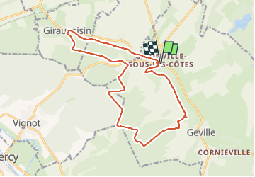
SityTrail - F739 La chapelle de Gévaux

ZAMBAUX
User

Length
17.2 km

Max alt
391 m

Uphill gradient
389 m
Km-Effort
22 km

Min alt
251 m

Downhill gradient
389 m
Boucle
Yes
Creation date :
2023-05-09 16:59:23.968
Updated on :
2023-07-28 13:57:59.485
5h04
Difficulty : Very difficult

FREE GPS app for hiking
 SityTrail
IGN / Geographical institutes
SityTrail Plus
The world is yours!
About
Trail Walking of 17.2 km to be discovered at Grand Est, Meuse, Geville. This trail is proposed by ZAMBAUX.
Description
Rando à faire sur la journée avec pique-nique à la chapelle
Positioning
Country:
France
Region :
Grand Est
Department/Province :
Meuse
Municipality :
Geville
Location:
Unknown
Start:(Dec)
Start:(UTM)
696357 ; 5407881 (31U) N.
Comments