


SityTrail - F739 bis La chapelle de Gévaux

ZAMBAUX
User
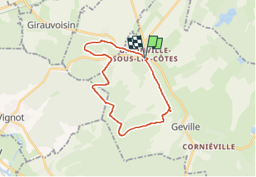

Length
12.5 km

Max alt
383 m

Uphill gradient
313 m
Km-Effort
16.7 km

Min alt
263 m

Downhill gradient
312 m
Boucle
Yes
Creation date :
2023-05-09 17:02:59.057
Updated on :
2023-05-09 17:05:29.319
3h47
Difficulty : Difficult

FREE GPS app for hiking
 SityTrail
IGN / Geographical institutes
SityTrail Plus
The world is yours!
About
Trail Walking of 12.5 km to be discovered at Grand Est, Meuse, Geville. This trail is proposed by ZAMBAUX.
Description
Circuit F739 raccourci de 19 à 13 km
Positioning
Country:
France
Region :
Grand Est
Department/Province :
Meuse
Municipality :
Geville
Location:
Unknown
Start:(Dec)
Start:(UTM)
696371 ; 5407877 (31U) N.
Comments