


Poncey tambourinette page 1 Jean Paul

grasgilbert
User

Length
6.4 km

Max alt
275 m

Uphill gradient
97 m
Km-Effort
7.7 km

Min alt
220 m

Downhill gradient
97 m
Boucle
Yes
Creation date :
2023-05-10 07:34:57.317
Updated on :
2023-05-10 07:37:38.517
1h45
Difficulty : Medium

FREE GPS app for hiking
 SityTrail
IGN / Geographical institutes
SityTrail Plus
The world is yours!
About
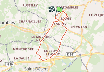
Trail Walking of 6.4 km to be discovered at Bourgogne-Franche-Comté, Saône-et-Loire, Givry. This trail is proposed by grasgilbert.
Positioning
Country:
France
Region :
Bourgogne-Franche-Comté
Department/Province :
Saône-et-Loire
Municipality :
Givry
Location:
Unknown
Start:(Dec)
Start:(UTM)
631509 ; 5181676 (31T) N.
Comments