


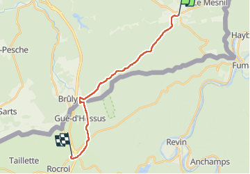
SJC3b Oignies-en-Thierache - Rocroi

thomarche
User

Length
16.5 km

Max alt
386 m

Uphill gradient
337 m
Km-Effort
21 km

Min alt
291 m

Downhill gradient
259 m
Boucle
No
Creation date :
2023-05-10 09:51:18.0
Updated on :
2023-05-10 15:14:45.514
4h25
Difficulty : Unknown

FREE GPS app for hiking
 SityTrail
IGN / Geographical institutes
SityTrail Plus
The world is yours!
About
Trail Walking of 16.5 km to be discovered at Wallonia, Namur, Viroinval. This trail is proposed by thomarche.
Description
Traversée au plus profond des bois jusqu’au Bruly. Beau décrochage de tout bruit mécanique. Plus aucun réseau téléphonique. Le pied. Choc arrivée autoroute d’autant plus grand… Savoir revenir des sommets…
Positioning
Country:
Belgium
Region :
Wallonia
Department/Province :
Namur
Municipality :
Viroinval
Location:
Unknown
Start:(Dec)
Start:(UTM)
617440 ; 5542468 (31U) N.
Comments