


Autour d'Etampes

jpcccb
User
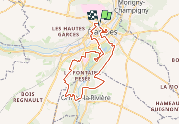

Length
16.6 km

Max alt
142 m

Uphill gradient
248 m
Km-Effort
19.9 km

Min alt
65 m

Downhill gradient
251 m
Boucle
Yes
Creation date :
2023-05-11 12:15:45.125
Updated on :
2024-03-11 15:00:33.22
4h31
Difficulty : Very difficult

FREE GPS app for hiking
 SityTrail
IGN / Geographical institutes
SityTrail Plus
The world is yours!
About
Trail Walking of 16.6 km to be discovered at Ile-de-France, Essonne, Étampes. This trail is proposed by jpcccb.
Description
Tour Guinette, tour du loup, base de loisirs, GR 655est, GRP les vallées de l'Essonne, centre ville.
Positioning
Country:
France
Region :
Ile-de-France
Department/Province :
Essonne
Municipality :
Étampes
Location:
Unknown
Start:(Dec)
Start:(UTM)
437835 ; 5365175 (31U) N.
Comments