


Étampes Etréchy

jpcccb
User
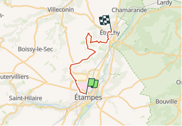

Length
14.5 km

Max alt
153 m

Uphill gradient
214 m
Km-Effort
17.4 km

Min alt
67 m

Downhill gradient
229 m
Boucle
No
Creation date :
2023-05-11 13:09:54.381
Updated on :
2023-11-05 17:12:41.56
3h56
Difficulty : Difficult

FREE GPS app for hiking
 SityTrail
IGN / Geographical institutes
SityTrail Plus
The world is yours!
About
Trail Walking of 14.5 km to be discovered at Ile-de-France, Essonne, Étampes. This trail is proposed by jpcccb.
Positioning
Country:
France
Region :
Ile-de-France
Department/Province :
Essonne
Municipality :
Étampes
Location:
Unknown
Start:(Dec)
Start:(UTM)
437819 ; 5365235 (31U) N.
Comments