


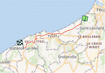
De Grainval à Vattetot à pied

planets
User

Length
6.8 km

Max alt
98 m

Uphill gradient
186 m
Km-Effort
9.2 km

Min alt
4 m

Downhill gradient
148 m
Boucle
No
Creation date :
2023-05-12 17:12:30.234
Updated on :
2023-05-12 17:12:32.728
2h05
Difficulty : Medium

FREE GPS app for hiking
 SityTrail
IGN / Geographical institutes
SityTrail Plus
The world is yours!
About
Trail Walking of 6.8 km to be discovered at Normandy, Seine-Maritime, Saint-Léonard. This trail is proposed by planets.
Positioning
Country:
France
Region :
Normandy
Department/Province :
Seine-Maritime
Municipality :
Saint-Léonard
Location:
Unknown
Start:(Dec)
Start:(UTM)
308883 ; 5513761 (31U) N.
Comments