


tour du Queyras Roger

LesAvins
User
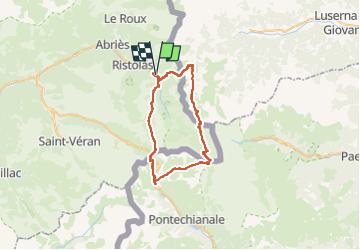

Length
46 km

Max alt
3035 m

Uphill gradient
3409 m
Km-Effort
91 km

Min alt
1662 m

Downhill gradient
3413 m
Boucle
Yes
Creation date :
2023-05-13 15:06:41.79
Updated on :
2023-05-13 15:07:37.158
20h46
Difficulty : Very difficult

FREE GPS app for hiking
 SityTrail
IGN / Geographical institutes
SityTrail Plus
The world is yours!
About
Trail Walking of 46 km to be discovered at Provence-Alpes-Côte d'Azur, Hautes-Alpes, Abriès-Ristolas. This trail is proposed by LesAvins.
Positioning
Country:
France
Region :
Provence-Alpes-Côte d'Azur
Department/Province :
Hautes-Alpes
Municipality :
Abriès-Ristolas
Location:
Ristolas
Start:(Dec)
Start:(UTM)
340782 ; 4958786 (32T) N.
Comments