


2023-05-14_1117237781_Circuit de course à pied à partir de Jouques

Kaiser113
User
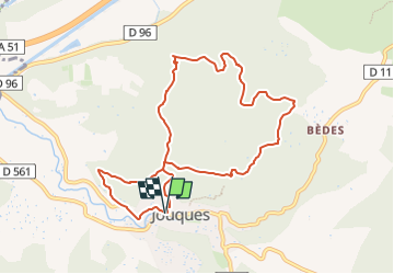

Length
9.7 km

Max alt
381 m

Uphill gradient
221 m
Km-Effort
12.7 km

Min alt
250 m

Downhill gradient
218 m
Boucle
Yes
Creation date :
2023-05-14 06:37:27.843
Updated on :
2023-05-14 06:52:31.952
--
Difficulty : Unknown

FREE GPS app for hiking
 SityTrail
IGN / Geographical institutes
SityTrail Plus
The world is yours!
About
Trail Trail of 9.7 km to be discovered at Provence-Alpes-Côte d'Azur, Bouches-du-Rhône, Jouques. This trail is proposed by Kaiser113.
Positioning
Country:
France
Region :
Provence-Alpes-Côte d'Azur
Department/Province :
Bouches-du-Rhône
Municipality :
Jouques
Location:
Unknown
Start:(Dec)
Start:(UTM)
712494 ; 4834935 (31T) N.
Comments